Consumer 3D Scanners vs Professional: Eagle vs Trimble X12 vs Xgrids L2 Pro
An expert comparison to help you choose the right equipment for your project.
| Feature | 3DMakerPro Eagle | Trimble X12 | Xgrids Lixel L2 Pro |
|---|---|---|---|
| Accuracy | 2cm at 10m; 3cm at 20m; 5cm at 40m | ±2mm at 20m | ±1-2cm relative; ±3cm absolute |
| Scan Speed | 200,000 points/second | 2,200,000 points/second | 320,000–640,000 pts/sec (16/32-channel) |
| Range | 80–140m (depending on reflectivity) | 0.2–130m (extendable to 300m) | 120m (standard); up to 300m (32-channel) |
| Weight | 1.5 kg (handheld) | ~5.8 kg (scanner head) | 1.7 kg (without battery) |
| Cameras | 1×48MP (Standard) / 4×48MP (Max) | - | Dual or quad 48MP panoramic |
| Output | PLY (point cloud + GS), OBJ, 8K panoramic | E57, RCP, LAS, PLY — direct BIM/CAD import | PLY, LCC (GS), E57 — Revit plugin available |
| Service Pricing | ~$4,000 (Standard) / ~$4,000+ (Max) | Professional-grade (contact manufacturer for pricing) | Professional-grade (contact manufacturer for pricing) |
Pricing shown reflects average US rates. Actual costs vary by location based on local market conditions, regulations, and project logistics — both within the US and internationally. Get a custom quote
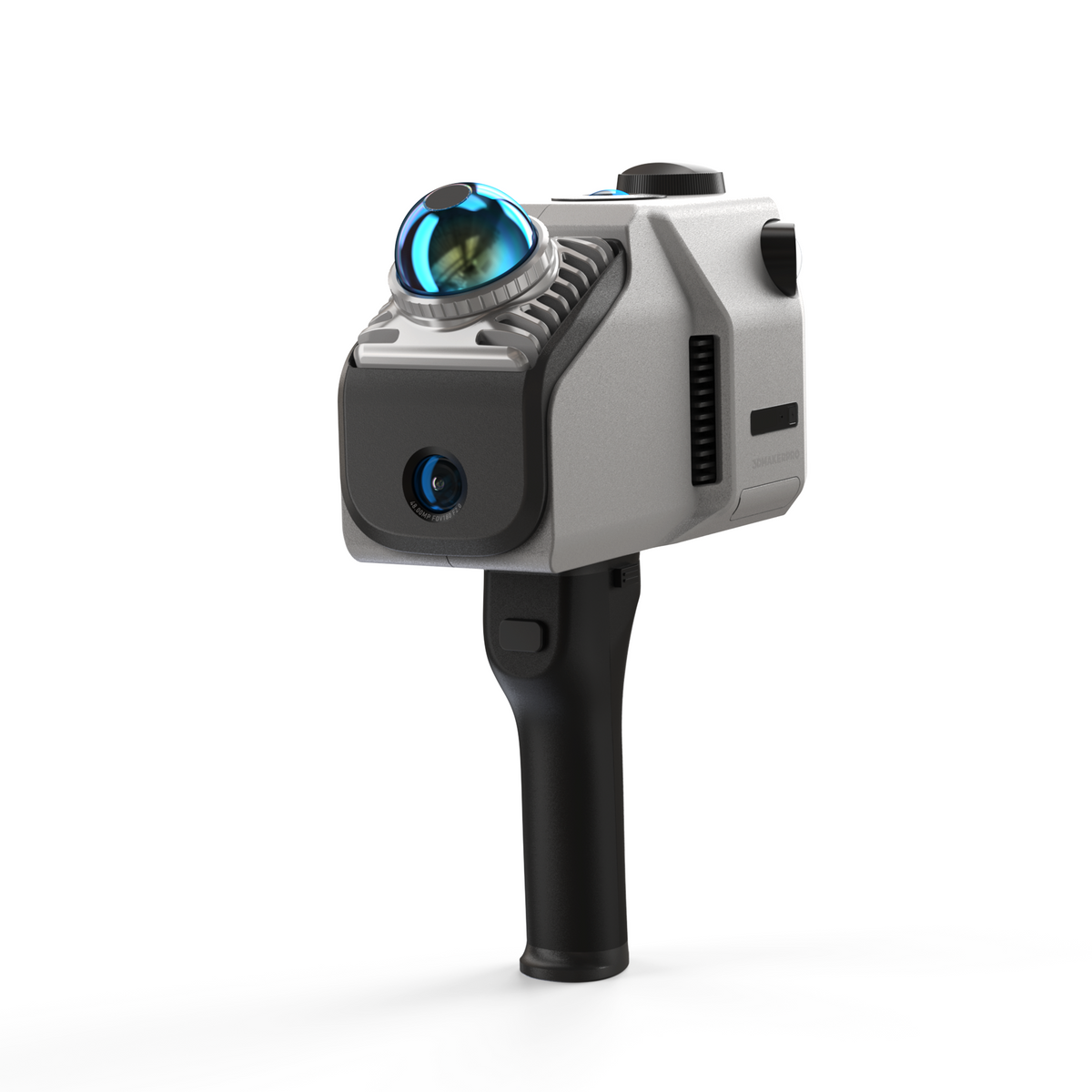
3DMakerPro Eagle
Affordable LiDAR Spatial Scanner for Building Environments
The 3DMakerPro Eagle is a consumer/prosumer handheld LiDAR scanner designed for large-scale environment capture. At approximately $4,000 (Standard) with a 1.5kg form factor, it brings building-scale 3D scanning to a price point accessible to architects, contractors, and content creators. The Eagle captures at 200,000 points per second with 2cm accuracy at 10m distance, and outputs PLY point clouds with Gaussian Splatting support and 8K HDR panoramic imagery via its proprietary software with AI denoising.
Pros
- Affordable entry point (~$4,000) for building-scale 3D scanning
- Lightweight and portable (1.5 kg, handheld, no tripod required)
- Native Gaussian Splatting output for photorealistic visualization
- 8K HDR panoramic imagery (Max edition with 4×48MP cameras)
- Built-in 3.5-inch live preview screen for real-time scanning feedback
- No calibration required — ready to use out of the box
Cons
- 2cm accuracy at 10m — insufficient for engineering measurement or survey work
- Accuracy degrades significantly beyond 20m (3cm at 20m, 5cm at 40m)
- No drone mode — ground-level capture only (cannot scan rooftops)
- Limited software ecosystem compared to professional platforms
- Noisy fan during operation (noted in independent reviews)
- Floor parallelism drift up to 10-20cm in multi-story scans
Best For
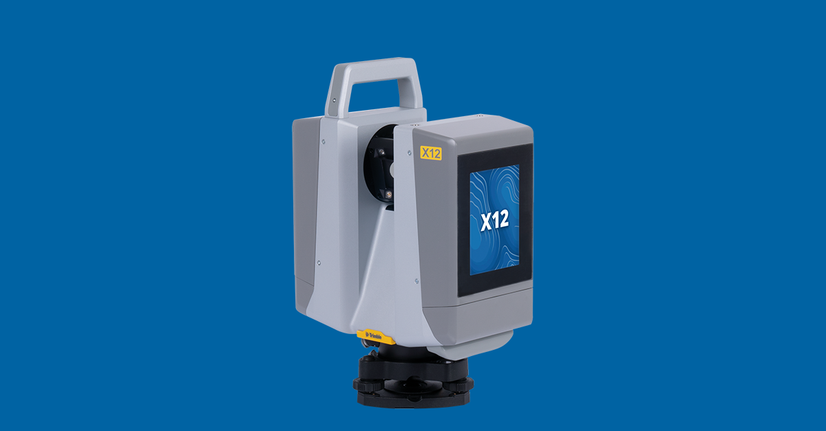
Trimble X12
Survey-Grade Terrestrial Laser Scanner for Engineering
The Trimble X12 is a professional terrestrial laser scanner representing the gold standard in survey-grade 3D capture. At 2.2 million points per second with ±1mm @ 10m / ±2mm @ 20m accuracy, the X12 delivers engineering-grade data for as-built documentation, construction coordination, and BIM workflows. Its 360° × 300° field of view captures full panoramic scans from each station, and integrated HDR photography provides colorized point clouds. The X12's output is immediately compatible with Trimble RealWorks, Autodesk Revit, AutoCAD, and other professional CAD/BIM software.
Pros
- Survey-grade ±2mm accuracy — accepted for engineering and regulatory documentation
- Fastest scan speed in class (2.2M pts/sec) for dense, detailed point clouds
- 360° panoramic capture eliminates repositioning in most scenarios
- Full CAD/BIM software compatibility (Revit, AutoCAD, Civil 3D, RealWorks)
- Established legal and regulatory acceptance for survey deliverables
- Robust quality control with detailed scan reports and accuracy verification
Cons
- High cost — designed for professional surveying firms and AEC companies
- Tripod-mounted and heavier than handheld alternatives
- No Gaussian Splatting output — produces point clouds and meshes only
- Requires trained operators and professional processing software
- Indoor/ground-level only — cannot capture aerial views or rooftops
- Setup time per station (~3-5 minutes) adds up for large projects
Best For
Xgrids Lixel L2 Pro
Professional Handheld SLAM Scanner with Native Gaussian Splatting
The Xgrids Lixel L2 Pro bridges the gap between consumer portability and professional capability. Available in 16-channel (320,000 pts/sec) and 32-channel (640,000 pts/sec) configurations with 120–300m range, the L2 Pro delivers ±1-2cm relative accuracy in a 1.7kg handheld form factor. Its unique advantage is native Gaussian Splatting output via LCC Studio alongside traditional point clouds via LixelStudio, plus the only commercially available Revit BIM plugin for GS data. With IP54 weather protection, 1TB SSD storage, and dual/quad 48MP panoramic cameras, the L2 Pro is designed for AEC professionals who need both measurement and visualization from a single device.
Pros
- Native Gaussian Splatting output alongside traditional point clouds
- Only commercially available Revit BIM plugin for GS data integration
- Professional-grade accuracy (±1-2cm) in a portable 1.7kg handheld form factor
- Long range (120-300m) handles building exteriors and large sites
- IP54 weather protection for outdoor field work
- Dual workflow: LCC Studio for GS visualization + LixelStudio for engineering point clouds
Cons
- Higher investment than consumer scanners
- Accuracy (±1-2cm) falls short of terrestrial scanners (±2mm) for tight-tolerance work
- Cloud processing via LCC Studio takes approximately 5 hours per model
- Smaller ecosystem and community compared to established scanner brands
- Battery life limited to approximately 90 minutes per charge
- Newer brand with less established service and support infrastructure
Best For
Our Expert Verdict
These three scanners serve different tiers of the market. The 3DMakerPro Eagle (~$4,000) democratizes building-scale 3D scanning for content creators and budget-conscious firms but lacks engineering accuracy. The Trimble X12 is the gold standard for survey-grade measurement but produces no GS output. The Xgrids L2 Pro bridges the gap with professional accuracy AND native Gaussian Splatting, plus the only Revit GS plugin — making it the most versatile choice for AEC firms that need both measurement and visualization.
Choose 3DMakerPro Eagle if...
Choose the 3DMakerPro Eagle when budget is the primary constraint and you need room-to-building-scale 3D capture for visualization, marketing, or non-regulatory documentation.
Choose Trimble X12 if...
Choose the Trimble X12 when engineering measurement accuracy is the non-negotiable requirement — survey-grade as-built documentation, construction coordination, legal/regulatory compliance, and projects where ±2mm accuracy matters more than photorealistic visualization.
Choose Xgrids Lixel L2 Pro if...
Choose the Xgrids L2 Pro when you need both professional-grade scanning accuracy AND Gaussian Splatting visualization — ideal for AEC firms that want to offer GS-enhanced deliverables alongside traditional point clouds, especially those using Revit for BIM workflows.
Frequently Asked Questions
Can the 3DMakerPro Eagle be used for professional AEC work?
For visualization and rough documentation, yes. For engineering measurement, regulatory compliance, or survey-grade deliverables, no. The Eagle's 2cm accuracy at 10m (degrading to 5cm at 40m) is insufficient for construction coordination or as-built documentation that requires ±1-5mm tolerance.
What makes the Xgrids L2 Pro unique?
The L2 Pro is the only handheld scanner that produces native Gaussian Splatting output alongside traditional point clouds, and it offers the only commercially available Revit plugin for GS data. This dual-output capability means AEC professionals can deliver both measurement-grade data AND photorealistic visualization from a single scan session.
Can any of these scanners capture from the air?
None of these are standalone drone scanners. For aerial capture, you need a drone system like the DJI Matrice 4E. The Xgrids L2 Pro does have a drone mounting mode for DJI M300/M350 RTK series for aerial SLAM scanning. For comprehensive building documentation, THE FUTURE 3D combines aerial drone GS with ground-level scanning.
What about the 3DMakerPro Eagle Max vs Standard?
The Eagle Max and Standard share identical LiDAR specifications (200,000 pts/sec, 2cm at 10m, 80-140m range). The key difference is cameras: Max has 4×48MP fisheye cameras for superior 8K HDR panoramic imagery, while Standard has 1×48MP. For projects where color and visual quality matter, the Max is worth the premium.
How do scan speeds compare in practice?
Trimble X12 captures 2.2M points/second from fixed tripod positions (full 360° scan in ~6 minutes). Xgrids L2 Pro captures 320-640K points/second while walking. 3DMakerPro Eagle captures 200K points/second while walking. In practice, handheld scanners cover more area per hour because they eliminate tripod setup time, but produce less dense point clouds per unit area.
Which scanner does THE FUTURE 3D use?
THE FUTURE 3D uses the Trimble X12 for survey-grade terrestrial scanning, the NavVis VLX 3 for rapid large-facility mobile scanning, and DJI enterprise drones for aerial photogrammetry and Gaussian Splatting. We select equipment based on project requirements. We do not scan individual objects — our services focus exclusively on buildings, environments, and locations.
Can I hire a professional service instead of buying a scanner?
Yes. Professional scanning services start at $0.20-$0.70/sqft for building documentation, with Gaussian Splatting as an add-on at 1.5× photogrammetry rates (minimum $2,250). For most businesses, hiring a professional service is more cost-effective than purchasing and maintaining scanning equipment. Contact THE FUTURE 3D for a project-specific quote.
Professional Equipment In This Comparison
The Future 3D operates all equipment featured in this comparison. We're certified professionals delivering expert results.
 Current Gen
3DMakerPro Eagle
Consumer Spatial LiDAR Scanner with Gaussian Splatting Output
 Current Gen
Trimble X12
Survey-Grade Precision Leader
 Current Gen
Xgrids Lixel L2 Pro
Handheld SLAM Scanner with Native Gaussian Splatting
Similar Equipment You Might Compare


Professional Services Using This Equipment
The Future 3D offers professional services utilizing 3DMakerPro Eagle and Trimble X12 for superior results.
3D Virtual Tours
Immersive Matterport virtual tours for properties and spaces
3D Laser Scanning
Millimeter-accurate point cloud capture with Trimble and NavVis
Scan-to-BIM
BIM-conversion-ready 3D laser scan data in E57, RCP, LAS, and OBJ
Digital Twins
Living 3D models with real-time IoT integration
As-Built Documentation
Registered point clouds, 360° panoramas, and PDF reports from 3D scanning
Google Street View
Google Trusted Photographer services for business interiors
Industries That Benefit From This Technology
3DMakerPro Eagle and Trimble X12 technology drives innovation across these key industries.
Schools & Education
Virtual campus tours, facility documentation, and safety planning
Real Estate
Immersive property tours and marketing assets
Retail
Store planning and virtual store tours
Hospitality
Hotel virtual tours and event space showcases
Insurance
Property documentation and claims support
Property Management
Portfolio documentation and move-in/out inspections
Available Nationwide
The Future 3D provides professional 3D scanning services across the United States.
Florida (Headquarters)
Northeast
West Coast
South & Midwest
Need Help Choosing?
Our experts can recommend the right equipment for your specific project requirements.