Alyssa’s Law refers to a series of state-level laws requiring schools to install silent panic alert systems that connect directly to local law enforcement during emergencies. Named after Alyssa Alhadeff, a 14-year-old student killed in the Marjory Stoneman Douglas High School shooting in Parkland, Florida on February 14, 2018, the legislation has been adopted in various forms across more than a dozen states. While most versions focus on panic alert technology, several states have expanded their school safety laws to include mapping mandates — requirements for schools to provide digital floor plans and interior documentation to first responders.
This guide explains what Alyssa’s Law requires, which states have adopted it, and how schools can comply with the mapping and documentation components using 3D laser scanning technology.
The Story Behind Alyssa’s Law
Alyssa Alhadeff was one of 17 people killed during the mass shooting at Marjory Stoneman Douglas High School in Parkland, Florida. In the aftermath, her mother Lori Alhadeff became a vocal advocate for school safety reform. Lori was elected to the Broward County School Board and founded the nonprofit Make Our Schools Safe to push for legislative changes at the state and federal level.
The core idea behind Alyssa’s Law is straightforward: every school building should have a way to silently and instantly alert law enforcement when an emergency occurs. Before these laws, many schools had no direct communication link to 911 dispatch during active threat situations. Teachers and staff had to manually call 911, often while hiding or evacuating — costing critical response time.
New Jersey became the first state to pass Alyssa’s Law (A764) in 2019, requiring all public schools to install silent panic alarm systems linked to local law enforcement. Since then, multiple states have followed with their own versions, each adapting the concept to their existing safety infrastructure.
Panic Alerts vs. Mapping Mandates: A Critical Distinction
When people talk about “Alyssa’s Law,” they are usually referring to the panic alert component — the requirement for schools to have systems that instantly notify police during emergencies. However, a growing number of states have passed separate but related legislation requiring schools to provide mapping data and floor plans to first responders.
These are distinct requirements:
Panic Alert Laws require schools to install technology (hardware, software, or mobile apps) that sends an immediate emergency signal to law enforcement. The signal typically includes the school’s address and sometimes the specific building or room. States with panic alert mandates include New Jersey, Florida (Alyssa’s Alert/SB 70), New York, Texas, Georgia, Oklahoma, Oregon, Utah, and Washington.
Mapping Mandates require schools to produce and share detailed digital maps, floor plans, and interior documentation with law enforcement, fire departments, and emergency management agencies. These maps allow first responders to pre-plan their response before an incident occurs — studying hallway configurations, entry points, room numbering, utility shutoffs, and evacuation routes. States with active mapping mandates or funded mapping programs include Texas, New Jersey, Virginia, West Virginia, Wisconsin, Florida, Georgia, Michigan, Indiana, Kentucky, Nebraska, Illinois, Minnesota, Louisiana, Maryland, and South Carolina.
Some states have both (like Texas and New Jersey), while others have only panic alerts (like Oregon) or only mapping grants (like Minnesota). The confusion arises because media coverage often lumps all school safety legislation under the “Alyssa’s Law” umbrella.
Which States Have Passed Alyssa’s Law or School Safety Mapping Legislation?
As of 2026, 16 states have active school safety mapping mandates or funded mapping programs. Here is a breakdown by category:
States with Active Mapping Mandates (Required by Law)
| State | Legislation | Key Requirement |
|---|---|---|
| Texas | TEC §37.108, HB 3 | All K-12 districts and charter schools must provide emergency response mapping to first responders |
| New Jersey | SB 2426 | Boards of education must provide critical incident mapping data to law enforcement |
| Virginia | Code 22.1-279.8 | Local school boards must create collaborative response graphics for safety audits |
| West Virginia | HB 3166 (2025) | County boards must develop standardized safety mapping data by September 2025 |
| Wisconsin | Act 109 | Every public and private school must submit blueprints to local law enforcement |
States with Funded Mapping Programs (Grant-Based)
| State | Legislation | Funding |
|---|---|---|
| Florida | HB 301 | $3,000–$5,000 per school |
| Georgia | HB 268 (2025) | $61,000 per school through FY 2026 |
| Michigan | Section 97c/97d, HB 6012 | Up to $1M per grantee |
| Indiana | HB 1492 | $5,000 per school |
| Nebraska | LB 1329 | $525,000–$4M |
| Illinois | Section 50 | Competitive grant |
| Minnesota | State allocation (2024) | $7M through June 2026 |
| Louisiana | School Safety Grant | $2.4M |
| Maryland | HB 0472 | Safe Schools Fund |
| South Carolina | Statewide contract | State-funded for 1,200+ schools |
| Kentucky | SB 2 | Varies |
States with Pending Legislation
- California: AB 598 (held in committee) — School Mapping Data Grant Program
- Ohio: SB 105 — Proposed panic alert systems with potential mapping components. “Alyssa’s law ohio” searches have increased 250% quarterly.
- Federal: Uniform School Mapping Act (introduced by Congressman Mast, not yet law)

What Does Alyssa’s Law Actually Require?
Requirements vary by state, but most mapping mandates share common technical specifications:
- Digital format — Paper blueprints are not sufficient. Maps must be in digital format accessible to multiple agencies.
- CAD/911/dispatch compatibility — Floor plans must integrate with existing computer-aided dispatch and NG9-1-1 systems.
- Room labeling — Every room, door, access point, and corridor must be clearly labeled with standardized nomenclature.
- Emergency asset locations — AEDs, fire extinguishers, cameras, utility shutoffs, and fire suppression systems must be mapped.
- Field verification — Maps must be verified through physical walkthroughs, not generated from outdated blueprints alone.
- Multi-agency usability — Law enforcement, fire departments, and EMS must all be able to use the documentation.
- Regular updates — Most states require annual or triennial updates as buildings undergo renovations.
- Printable AND digital — First responders need both screen-accessible and printable versions.
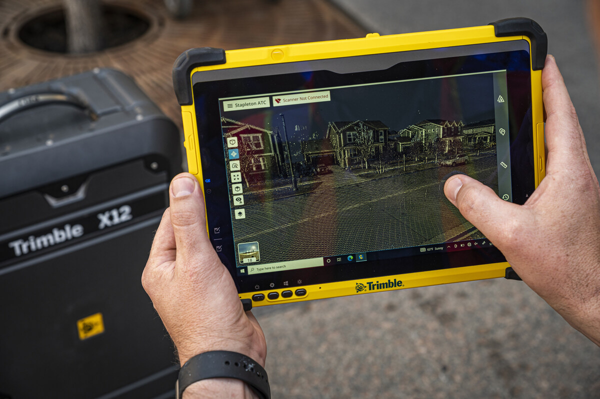
Texas has the most detailed requirements, specifying that maps must be field-verified with true-north orientation, aerial imagery overlays, point cloud data, and room-by-room labeling of life safety assets. The Texas Education Agency (TEA) maintains an Emergency Response Campus Mapping Vendor Directory and conducts triennial compliance audits through the Sentinel system.
How Schools Comply with Mapping Requirements
For schools facing mapping mandates, the question becomes: how do you produce the required documentation?
Most school buildings are decades old. Original blueprints — if they exist at all — are outdated, inaccurate, or don’t reflect renovations. Many schools have no current floor plans whatsoever. Creating compliant documentation from scratch requires capturing the building’s actual current condition.
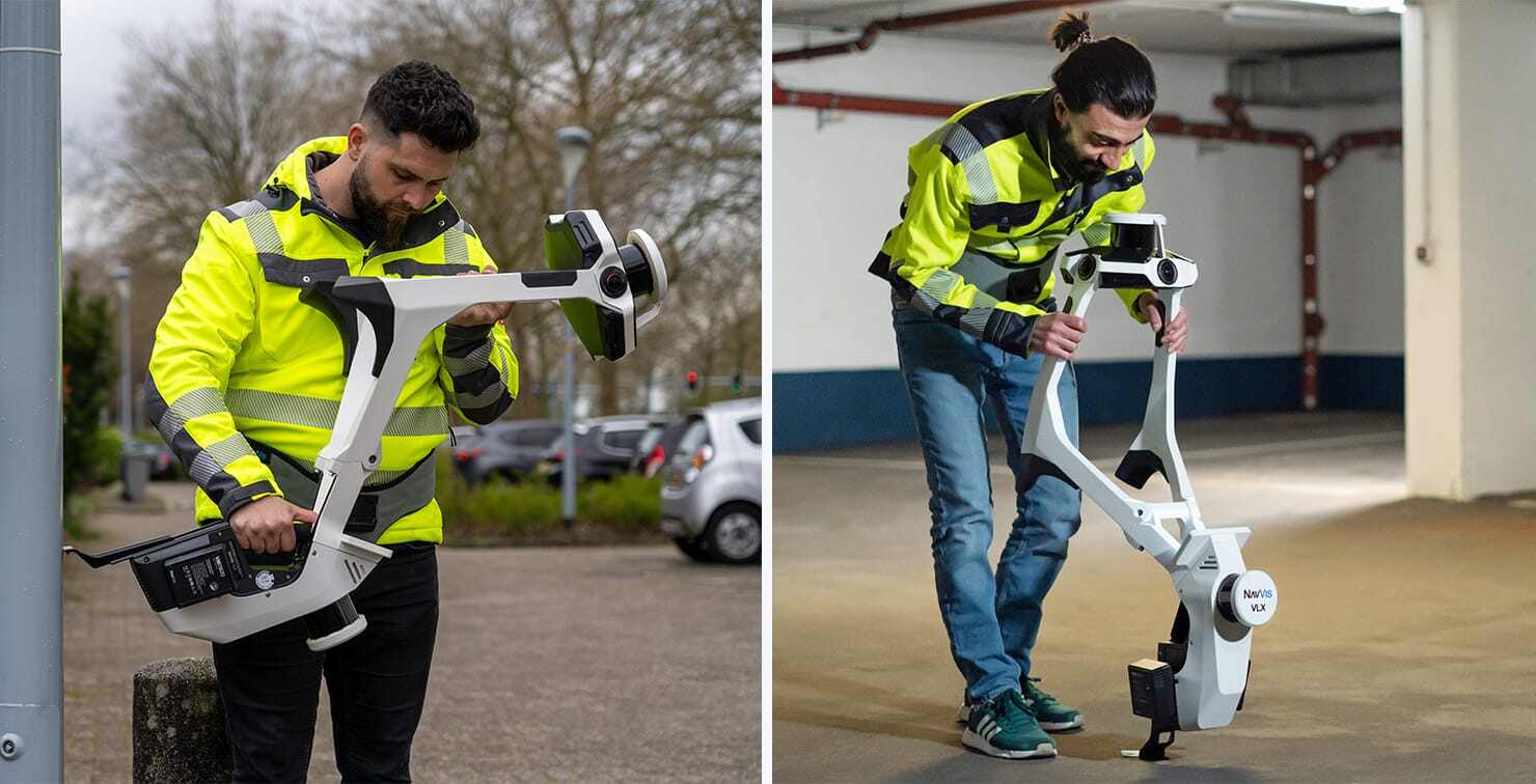
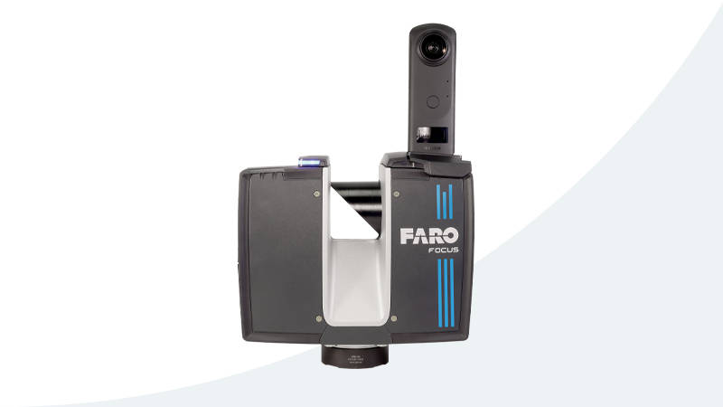
3D laser scanning is the most efficient and accurate method for producing this documentation. A survey-grade laser scanner like the Trimble X12 (±2mm accuracy) or FARO Focus Premium captures millions of precise measurements of a building’s interior in a single visit. The resulting point cloud data can be converted into:
- CAD floor plans (DWG/DXF format) — compatible with 911 dispatch systems
- Room measurements with door locations, access points, and corridor widths
- Emergency asset overlays — fire extinguishers, AEDs, cameras, utility shutoffs
- Multi-format exports — E57, RCP, LAS, DWG/DXF for different agency needs
The scanning process itself serves as the field verification walkthrough that most states require. Unlike manually measuring rooms with tape measures, 3D scanning captures comprehensive surface data, ensuring no detail is missed.
For schools that also need marketing documentation, a single site visit can produce both safety deliverables (point cloud data, floor plans) and marketing deliverables (a Matterport 3D virtual tour for enrollment marketing). This dual-purpose approach maximizes the value of the scanning investment.
How Much Does Compliance Cost?
School safety 3D documentation using laser scanning typically costs $0.20–$0.70 per square foot with a $1,000 minimum project size.
For context:
- A 25,000 sqft elementary school: $5,000–$10,000
- A 50,000 sqft middle school: $10,000–$20,000
- A 100,000 sqft high school: $20,000–$40,000
Matterport virtual tours for schools start at $1,500 per building.
The cost per building drops significantly for multi-school district contracts. A district scanning 10 elementary schools of similar size would pay considerably less per building than a single-school project.
For a detailed breakdown, see our school safety mapping cost guide.
Funding Sources for School Safety Mapping
A common misconception is that federal grants like the STOP School Violence Program ($83M in FY25) or COPS School Violence Prevention Program ($73M in FY25) fund mapping and scanning services. They do not. Federal grants focus on training, threat assessment, anonymous reporting, and prevention programs — not physical documentation or mapping.
School safety mapping is funded at the state level. The major state funding sources include:
- Texas SAFE Grant: $800M+ for school safety including emergency response mapping
- Georgia HB 268: $61,000 per school through FY 2026
- Minnesota: $7M administered through regional emergency communication boards (through June 2026)
- Florida HB 301: $3,000–$5,000 per school for field-verified mapping data
- Indiana HB 1492: $5,000 per school through Secured School Safety Grant
- Michigan Section 97c/97d: Up to $1M per grantee
- Nebraska LB 1329: $525,000–$4M through School Emergency Response Mapping Fund
Schools should check with their state’s department of education for current grant availability and application deadlines. For a comprehensive guide, see our state grants funding guide.
Frequently Asked Questions
What states have adopted Alyssa’s Law?
More than a dozen states have adopted versions of Alyssa’s Law or related school safety legislation. For panic alerts: New Jersey, Florida, Texas, Georgia, New York, Oklahoma, Oregon, Utah, and Washington. For mapping mandates or funded mapping programs: Texas, New Jersey, Virginia, West Virginia, Wisconsin, Florida, Georgia, Michigan, Indiana, Kentucky, Nebraska, Illinois, Minnesota, Louisiana, Maryland, and South Carolina. Some states have both panic alert and mapping requirements.
Is Alyssa’s Law a federal law?
No. Alyssa’s Law is state-level legislation. Each state that has adopted it has passed its own version with state-specific requirements. The federal ALYSSA Act was introduced in Congress but has not been signed into law. A separate Uniform School Mapping Act was also introduced federally but remains in committee.
Who is Alyssa’s Law named after?
Alyssa’s Law is named after Alyssa Alhadeff, a 14-year-old student who was killed in the Marjory Stoneman Douglas High School shooting in Parkland, Florida on February 14, 2018. Her mother, Lori Alhadeff, became a leading advocate for school safety reform and founded the nonprofit Make Our Schools Safe.
Does Alyssa’s Law require floor plans?
It depends on the state. The original Alyssa’s Law (NJ A764) focuses on panic alert systems and does not specifically require floor plans. However, New Jersey also passed SB 2426 separately, which does require mapping data. Texas, Virginia, West Virginia, and Wisconsin have active mandates requiring schools to provide floor plans and mapping data to first responders. States like Florida, Georgia, and Michigan fund mapping programs through grants.
What is the difference between Alyssa’s Law and Alyssa’s Alert?
Alyssa’s Alert is the specific name used in Florida (SB 70, 2020) for the panic alert requirement. Florida’s version is distinct from the mapping provisions in HB 301, which funds digital school maps. In contrast, “Alyssa’s Law” is the broader term used across multiple states. Georgia’s HB 268 is named “Ricky and Alyssa’s Law” and includes both panic alerts and mapping requirements in a single bill.
How does 3D scanning help schools comply with Alyssa’s Law mapping mandates?
3D laser scanning captures precise measurements of a school building’s interior, producing point cloud data that can be converted into CAD floor plans, room layouts, and emergency asset maps. The scanning process itself serves as the field verification walkthrough required by most state mandates. The resulting documentation meets technical requirements for CAD/911 compatibility, room labeling, emergency asset mapping, and multi-agency usability. Our scanning services produce documentation that meets state mapping requirements — schools receive the data deliverables needed for compliance.
How much does school safety scanning cost?
3D laser scanning for school safety documentation typically costs $0.20–$0.70 per square foot with a $1,000 minimum project size. Schools have relatively open layouts, so most fall in the $0.20–$0.40/sqft range. A standard 50,000 sqft school building costs approximately $10,000–$20,000. Matterport virtual tours for schools start at $1,500 per building. Many states offer grants that partially or fully offset these costs. See our compliance checker tool to find your state’s available funding.
Can the same scan serve both safety and marketing purposes?
Yes. A single on-site visit can produce both safety documentation (point cloud data, floor plans for first responders) and marketing documentation (a Matterport 3D virtual tour for enrollment marketing). The laser scan data goes to your local fire and police departments. The virtual tour goes on your school website for prospective families. This dual-purpose approach maximizes the value of the scanning investment.
What deliverables do schools receive?
Schools receive point cloud data files (E57, RCP, LAS formats), CAD-compatible floor plans (DWG/DXF), room measurements, door and access point locations, and emergency asset mapping overlays. If a Matterport tour is included, schools also receive an interactive 3D virtual tour with a shareable link. All deliverables are provided in formats compatible with CAD/911 dispatch systems as required by state mandates.
Are private and charter schools included in Alyssa’s Law?
In most states, yes. Texas specifically includes open-enrollment charter schools. New Jersey covers both public and nonpublic schools. Wisconsin requires both public and private schools to submit blueprints. Georgia’s HB 268 applies broadly. However, coverage varies by state — check your state’s specific requirements for details.
All legislation data in this article was verified using official state sources, the Texas Education Agency, CRG Plans state funding database, GeoComm school mapping reports, and Datamark GIS state analysis. For state-specific compliance details, visit our state compliance guides or use our compliance checker tool.
Ready to Start Your Project?
Get a free quote and consultation from our 3D scanning experts.
Get Your Free Quote