Exploring the Latest Use Cases of DroneDeploy with THE FUTURE 3D
The integration of cutting-edge drone technology in various industries has revolutionized how businesses operate and gather data. At THE FUTURE 3D, we pride ourselves on being at the forefront of this technological wave, providing top-notch drone services that enhance precision, efficiency, and safety in numerous fields. Leveraging the powerful capabilities of DroneDeploy, a leading drone software platform, we offer unparalleled services that set us apart in the industry. Here are some of the latest use cases of DroneDeploy that showcase the transformative impact of our drone services.
1. Construction Site Management
DroneDeploy’s advanced mapping and analytics capabilities are invaluable for construction site management. At THE FUTURE 3D, we use DroneDeploy to create detailed 3D models and orthomosaic maps of construction sites, allowing project managers to monitor progress with precision. This real-time data helps in identifying potential issues, optimizing resource allocation, and ensuring projects stay on schedule and within budget. By providing a comprehensive aerial view, we enable better decision-making and enhance overall project efficiency.
2. Agricultural Monitoring
Agriculture has seen significant advancements with the use of drone technology, and DroneDeploy is at the heart of this transformation. Our services at THE FUTURE 3D include crop health analysis, field mapping, and irrigation management. Using DroneDeploy, we deliver detailed insights into crop conditions, helping farmers make informed decisions about planting, fertilizing, and harvesting. This precision agriculture approach reduces waste, increases yields, and promotes sustainable farming practices.

3. Roof Inspections
Roof inspections have traditionally been time-consuming and hazardous. With DroneDeploy, we streamline this process, making it faster, safer, and more accurate. THE FUTURE 3D uses drones equipped with high-resolution cameras and thermal sensors to conduct thorough inspections of residential and commercial roofs. This technology allows us to detect issues such as leaks, cracks, and insulation problems without the need for manual inspections. Our clients benefit from detailed reports and actionable insights, enabling timely maintenance and repairs.
4. Environmental Conservation
Environmental conservation efforts have greatly benefited from drone technology, and DroneDeploy plays a crucial role in this domain. At THE FUTURE 3D, we assist conservationists in monitoring wildlife habitats, tracking animal movements, and assessing environmental changes. The data collected through DroneDeploy is used to create detailed maps and 3D models, aiding in the development of conservation strategies. This technology allows for non-intrusive monitoring, ensuring minimal disturbance to wildlife.
5. Disaster Response and Management
In times of disaster, quick and accurate data collection is critical for effective response and recovery. THE FUTURE 3D leverages DroneDeploy to provide rapid aerial assessments of disaster-stricken areas. Our drones capture high-resolution images and generate 3D models that help emergency responders assess damage, plan rescue operations, and allocate resources efficiently. This technology is instrumental in minimizing response times and improving the overall effectiveness of disaster management efforts.
6. Real Estate and Property Management
The real estate industry is another sector where DroneDeploy has made significant inroads. At THE FUTURE 3D, we use drones to create stunning aerial photography and 3D virtual tours of properties. These visuals provide potential buyers with a comprehensive view of the property, enhancing the marketing efforts of real estate agents. Additionally, DroneDeploy’s precise mapping capabilities are used for property inspections, land surveys, and development planning.
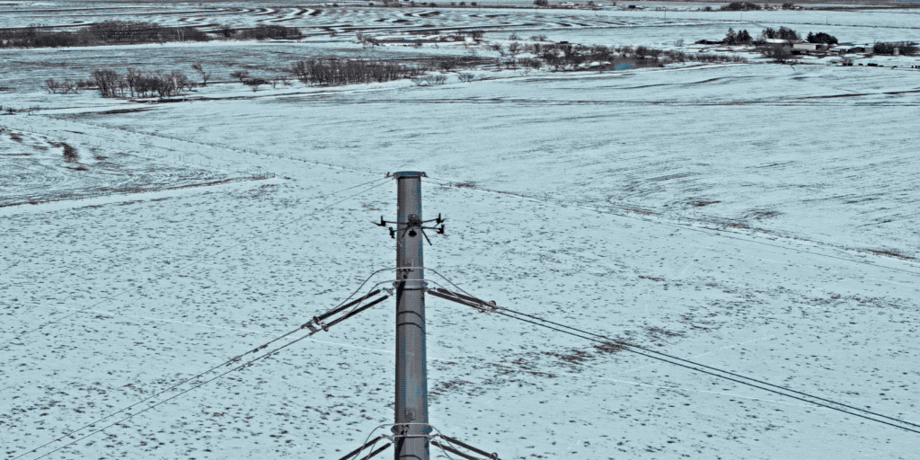
7. Infrastructure Inspection
Inspecting infrastructure such as bridges, power lines, and pipelines is a challenging and often dangerous task. DroneDeploy enables us to conduct these inspections safely and efficiently. At THE FUTURE 3D, our drones capture high-resolution imagery and thermal data, identifying structural issues and areas of concern. This information is crucial for maintenance planning and ensuring the safety and reliability of critical infrastructure.
Conclusion
At THE FUTURE 3D, we are dedicated to harnessing the full potential of DroneDeploy to deliver exceptional drone services across various industries. Our expertise and innovative approach make us the go-to provider for precision data collection and analysis. Whether you are in construction, agriculture, real estate, or environmental conservation, our drone services can elevate your operations to new heights. Visit thefuture3d.com to learn more about how we can help you achieve your goals with the power of DroneDeploy.
Ready to Start Your Project?
Get a free quote and consultation from our 3D scanning experts.
Get Your Free Quote

