THE FUTURE 3D
America's Premier 3D Scanning and Drone Service Company
Complete 3D Scanning & Drone Services Under One Roof
From initial scanning to final deliverables, we provide end-to-end 3D capture and modeling services tailored to your industry.
THE FUTURE 3D Advantage
We combine cutting-edge technology with local expertise to deliver unmatched 3D scanning and drone services. Here's what sets us apart:
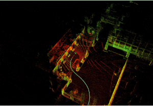
3D Laser Scanning in Action
Watch how we capture millimeter-accurate point clouds
Nationwide + International Service
America's premier 3D Scanning company with rapid deployment nationwide and international capabilities.
Complete 8-Service Integration
One team for all your 3D needs. From virtual tours to scan-to-BIM, we deliver seamless, integrated solutions for interiors and exteriors.
1-Hour Response Time
We treat every client as a priority. Our commitment to professionalism means rapid response times so your project stays on schedule.
Enterprise-Grade Technology
Trimble, NavVis, Matterport, DJI, Skydio — we use the industry's most advanced equipment for survey-grade precision.
Expertise Across Every Industry
From architecture to utilities, we understand the unique challenges and requirements of your industry. Our specialized solutions deliver measurable results.
Our Latest Projects
Click any project to explore in immersive 3D. Real tours from our portfolio.
Your Project, Simplified
From initial consultation to final delivery, our streamlined process ensures exceptional results every time.
Consultation
We discuss your project requirements, goals, and timeline. We respond within 1 hour.
Site Assessment
Our team evaluates the location and determines the optimal equipment and approach.
Data Capture
Professional 3D scanning, photography, and drone capture using industry-leading equipment.
Processing
Expert processing and quality control to ensure millimeter-accurate deliverables.
Delivery
Receive your files in multiple formats with comprehensive documentation and training.
Ready to get started? Let's discuss your project.
Enterprise-Grade Equipment
We invest in the industry's most advanced scanning, imaging, and drone technology to deliver survey-grade accuracy on every project.
Matterport Pro3
The gold standard for immersive 3D Virtual Tour experiences and precise as-built documentation.
- 4K HDR Capture
- LiDAR Sensor
- AI Processing
Trimble X12 / X9 / X7
Survey-grade terrestrial scanners for precise as-built documentation and BIM modeling.
- 2mm to 5mm Accuracy
- Point Cloud to CAD/BIM
- Large Area Coverage
NavVis VLX3 / MLX
SLAM-based mobile mapping for rapid large facility documentation without interrupting operations.
- Walk-Through Capture
- 200,000-300,000 sqft/day
- No Business Disruption
DJI Matrice 4E/T & M400 RTK
Enterprise drone fleet for aerial photogrammetry, thermal inspections, and precision LiDAR mapping.
- Centimeter Accuracy
- Map 100+ Acres Per Day
- Thermal + RGB + LiDAR
DJI Zenmuse L3 + P1
Combined LiDAR and photogrammetry modules for comprehensive Aerial Mapping.
- See Through Vegetation
- Map 400+ Acres/Flight
- Survey-Grade
Skydio X10 & R10
American-made autonomous drones for complex inspection missions requiring government compliance.
- AI-Powered Safety
- American-Made
- Government Compliant
Certified & Insured
All equipment is professionally maintained and calibrated. Our team is FAA Part 107 certified and fully insured for your protection.
Equipment Comparison Guides
Make informed decisions with our detailed technology comparisons
Nationwide Service Coverage
From coast to coast, our teams deliver professional 3D scanning and drone services with local expertise
Projects Completed
Across all 50 states and international
Client Satisfaction
Based on post-project surveys
Response Time
For quotes and inquiries
Integrated Services
All under one roof
Trusted by architects, engineers, and developers nationwide since 2018
Trusted by Industry Leaders
See why architects, developers, and facility managers nationwide choose THE FUTURE 3D.
Trusted by Leading Organizations
Common Questions
Find answers to frequently asked questions about our services, pricing, and process.
Can't find what you're looking for?
Contact our teamReady to Capture Your Space in Stunning 3D?
Join 300+ satisfied clients nationwide and internationally who trust THE FUTURE 3D for professional 3D scanning, Virtual Tours, and Digital Twin solutions.