Drone Photogrammetry
Transform aerial imagery into precise 3D terrain models, orthomosaic maps, and volumetric data. Our FAA Part 107 certified pilots operate enterprise DJI M350 RTK drones delivering survey-grade accuracy for construction, land development, and site documentation. Track construction progress, calculate cut/fill volumes, and create GIS-ready deliverables.
See It In Action
Watch our drone photogrammetry technology at work.
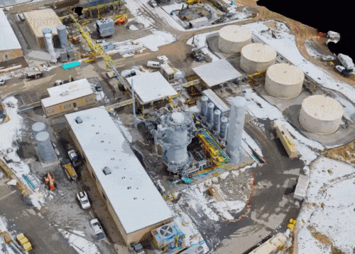
Construction Site Mapping
Aerial photogrammetry for construction progress monitoring
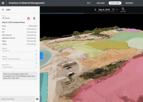
Volume Calculation
Accurate stockpile and cut/fill volume measurements
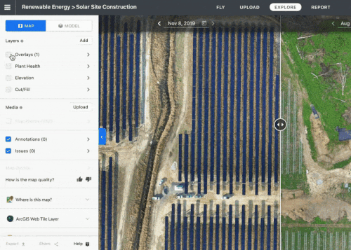
Construction Timeline
Track project progress over time with aerial documentation
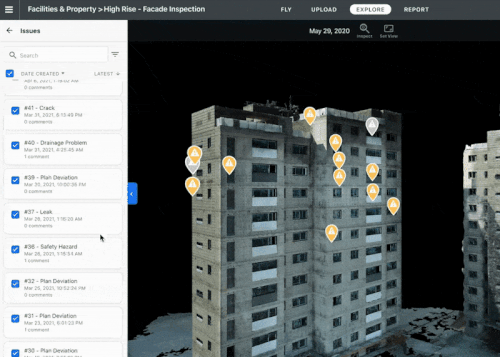
Facade Documentation
High-resolution building facade mapping
Key Features
Industry-leading capabilities that set our drone photogrammetry services apart.
RTK Positioning
Centimeter-level accuracy with real-time kinematic GPS and mechanical shutter cameras (M4E, P1) for distortion-free imagery.
Orthomosaic Maps
True-scale aerial imagery stitched into seamless base maps.
3D Terrain Models
Digital Surface Models (DSM) and Digital Terrain Models (DTM).
Volume Calculations
Accurate cut/fill and stockpile volume measurements.
Progress Monitoring
Regular flyovers to track construction progress over time.
GIS Integration
Deliverables in GeoTIFF, DXF, and standard GIS formats.
Our Process
A streamlined workflow designed to deliver exceptional results.
Flight Planning
Define area, accuracy requirements, and deliverables.
Ground Control
Set survey-grade ground control points if required.
Flight & Capture
FAA-certified pilots execute the flight mission.
Processing
Photogrammetric processing and deliverable generation.
What You'll Receive
- Orthomosaic (GeoTIFF)
- Digital Surface Model
- Digital Terrain Model
- Contour Lines
- 3D Mesh
- Volume Report
Key Benefits
- Survey large areas quickly
- Safer than manual surveying
- Accurate volumetric data
- Track construction progress
- Create base maps for design
- Document site conditions
RTK-corrected drone photogrammetry achieves 2-3 cm accuracy across hundreds of acres in a single day. That kind of coverage and precision was impossible five years ago without a full field crew and weeks of work.
Drone Photogrammetry vs Traditional Survey
| Factor | Drone Photogrammetry | Traditional Ground Survey |
|---|---|---|
| Accuracy | 2–5 cm with GCPs/RTK | 1–2 cm with total station |
| Speed (10 acres) | 2–4 hours | 2–3 days |
| Cost (10 acres) | $1,500–$3,000 | $5,000–$15,000 |
| Deliverables | Orthomosaic, DSM, DTM, 3D mesh | Topo map, boundary plat |
| Vegetation | Cannot penetrate canopy | Manual clearing required |
Industries We Serve
Our drone photogrammetry services support professionals across these industries.
Frequently Asked Questions
What accuracy do you achieve?
With RTK and ground control, we achieve 1-2cm horizontal and 2-3cm vertical accuracy.
How large an area can you map?
We regularly map sites from 1 acre to 1,000+ acres in a single day.
Do you need ground control points?
For survey-grade accuracy, yes. For general mapping, our RTK drones provide sufficient accuracy.
Pricing shown reflects average US rates. Actual costs vary by location based on local market conditions, regulations, and project logistics — both within the US and internationally. Get a custom quote
Add Photorealistic 3D Visualization
Transform the same aerial drone data into photorealistic Gaussian Splatting scenes that render at 100+ FPS. GS processing adds real-time visualization alongside your standard photogrammetry deliverables.
Learn More
Explore guides and answers related to drone photogrammetry.
Drone Photogrammetry Available Nationwide
Our drone photogrammetry services are available across all 50 states and select international locations. Select your city for local pricing and availability.
Explore 400+ locations across the United States & internationally
Ready to Get Started?
Request a custom quote for your drone photogrammetry project. We typically respond within 1 hour to discuss your project needs.