Gaussian Splatting produces photorealistic 3D scenes that render at 100+ FPS — but how accurate are they? The answer depends on what you mean by “accuracy,” because GS excels at one type and falls short on another. Understanding this distinction is critical for any professional considering GS for a project where measurements matter.
This guide breaks down GS accuracy into its two components, provides benchmark comparisons against LiDAR, photogrammetry, and structured-light methods, identifies which applications GS accuracy supports and which it does not, and explains the hybrid approach that combines GS visual fidelity with survey-grade dimensional precision.
Two Types of Accuracy
Gaussian Splatting accuracy must be evaluated on two independent axes that are frequently conflated:
Visual Fidelity (Rendering Accuracy)
Visual fidelity measures how closely the rendered GS scene matches the appearance of the real-world scene — the colors, textures, lighting, material properties, and spatial relationships as perceived by a human viewer. GS excels here. By representing scenes as millions of overlapping Gaussian ellipsoids that blend smoothly during rendering, GS produces images that are often indistinguishable from photographs at rendering speeds exceeding 100 FPS.
Standard metrics for visual fidelity include:
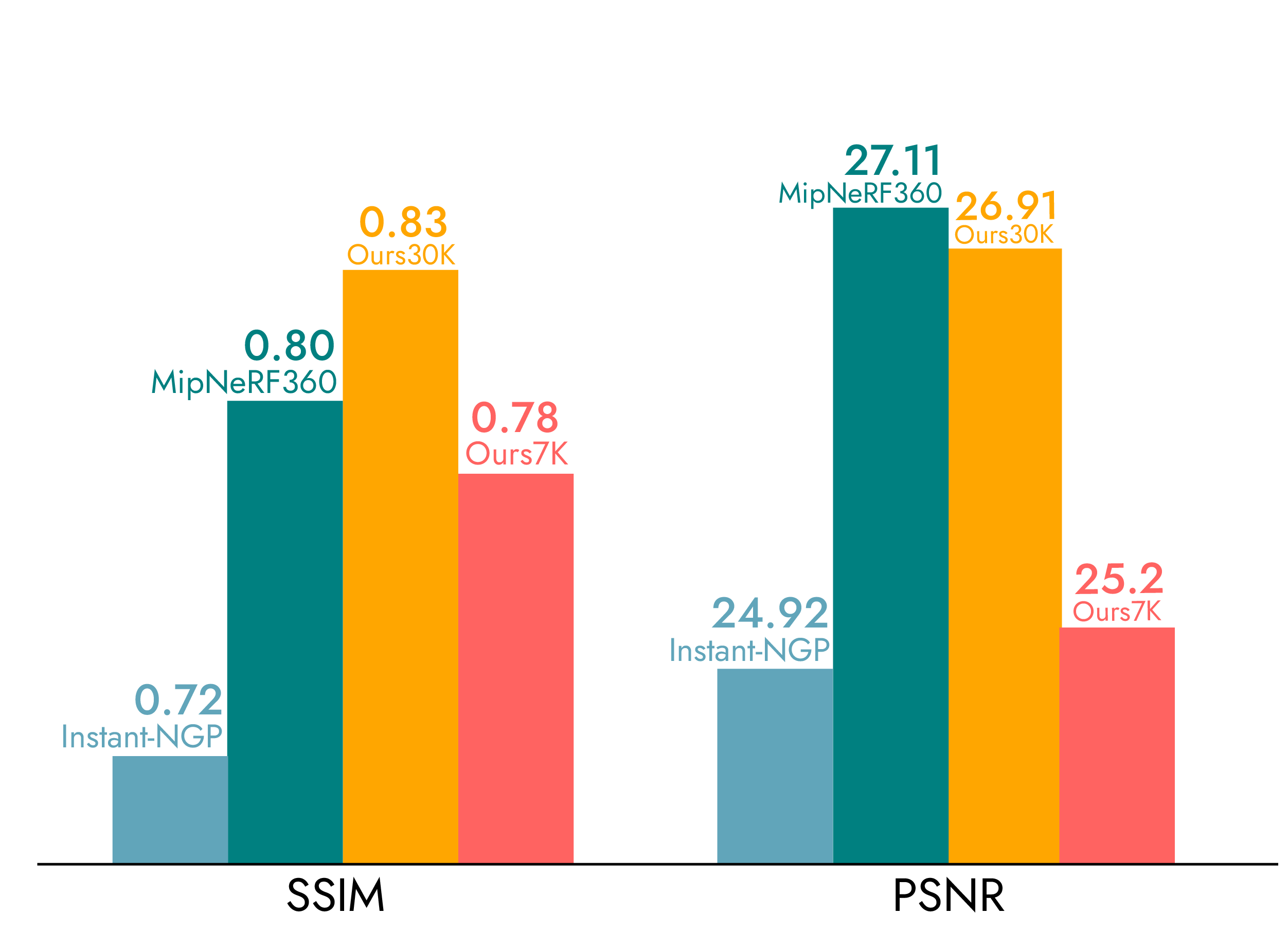
- PSNR (Peak Signal-to-Noise Ratio): GS typically achieves 25–35 dB on benchmark scenes, consistently outperforming mesh-based photogrammetry and competing with or exceeding NeRF methods
- SSIM (Structural Similarity Index): GS scores 0.85–0.95 on standard benchmarks, indicating high structural similarity to ground-truth photographs
- LPIPS (Learned Perceptual Image Patch Similarity): GS achieves low LPIPS scores (0.05–0.15), indicating perceptual similarity to real images
For applications where the goal is visual representation — client presentations, marketing materials, virtual tours, design review, film environments — GS visual fidelity is excellent and often superior to alternatives.
Geometric Accuracy (Dimensional Precision)
Geometric accuracy measures how closely the 3D positions of reconstructed surfaces match the actual physical positions of those surfaces in the real world. This is where GS has measurable limitations.
The most cited benchmark figure is a mean geometric error of 7.82cm ± 11.49cm, reported in comparative studies evaluating GS reconstruction against ground-truth LiDAR reference scans. This means that, on average, a surface reconstructed via GS is approximately 8 centimeters away from its true position — with significant variance (the ± 11.49cm standard deviation indicates some areas are much better and some are much worse).
Recent research from 2024–2025 has shown context-dependent accuracy variations:
- Urban building scenes with the Prior-Guided GS method (GS4B) demonstrated improved geometric accuracy over baseline approaches, though absolute accuracy depends heavily on input data quality
- Photogrammetric evaluations report mean cloud-to-cloud residual errors between LiDAR and photogrammetric point clouds of 6.7–8.5cm — consistent with the 7.82cm GS benchmark
- High-overlap datasets (70%+ image overlap) with COLMAP-based structure-from-motion can reduce GS errors by up to 9% compared to lower-overlap captures
The fundamental constraint is that GS is optimized for rendering quality, not geometric precision. The training process minimizes photometric loss (difference between rendered and actual images) rather than geometric loss (distance between reconstructed and actual 3D positions). Gaussians shift, stretch, and adjust to produce visually correct renderings — even if their 3D positions do not perfectly correspond to physical surfaces.
Accuracy Comparison: GS vs. Everything Else
| Method | Geometric Accuracy | Visual Quality | Speed | Best For |
|---|---|---|---|---|
| 3D Gaussian Splatting | 7.82cm mean error | Photorealistic (100+ FPS) | Fast processing | Visualization, marketing, VP |
| Mesh Photogrammetry | 1–3cm with GCPs | Good (texture mapping) | Medium processing | Survey, mapping, measurement |
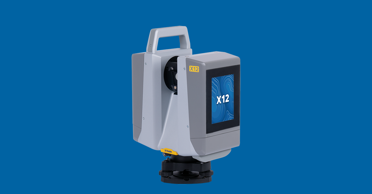
| Terrestrial LiDAR (Trimble X12) | ±2mm at 20m | Point cloud only | Fast capture, medium processing | Engineering, construction, as-built |
| Mobile SLAM (NavVis VLX 3) | ±5mm | Point cloud + panoramic | Fast capture | Indoor documentation, facilities |
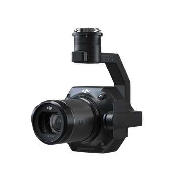
| Drone LiDAR (Zenmuse L3) | ±1–3cm | Point cloud only | Fast capture | Terrain, corridor mapping |
| Matterport | ~1% dimensional accuracy | Structured panoramic | Fast capture | Real estate, interior |
| Structured Light | 0.01–0.1mm | Surface mesh | Slow (object scale) | Manufacturing, quality control |

Several things stand out from this comparison:
-
GS is the least geometrically accurate method that is still useful for professional applications. Its accuracy is 3–10× worse than photogrammetry and 40–4,000× worse than LiDAR. This is not a flaw — it is a design trade-off. GS optimizes for visual quality and rendering speed, not dimensional precision.
-
GS produces the best visual output of any method. No other 3D capture method produces renderings as photorealistic as GS at real-time frame rates. LiDAR produces point clouds that require significant post-processing to visualize. Photogrammetry meshes have texture mapping artifacts. Matterport stitches panoramic images rather than reconstructing true 3D geometry.
-
The accuracy gap is why hybrid workflows exist. Combining GS (best visual quality) with LiDAR (best geometric accuracy) gives clients both photorealistic visualization AND engineering-grade measurement from the same capture session.
Factors That Affect GS Accuracy
GS geometric accuracy is not a fixed constant — it varies significantly based on capture and processing conditions.
Image Overlap and Coverage
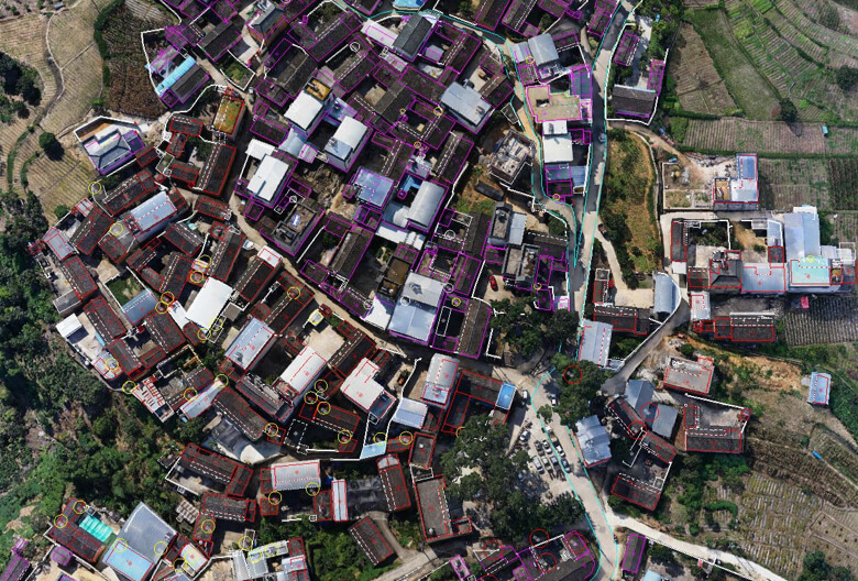
Higher image overlap produces better Structure from Motion (SfM) reconstruction, which serves as the initialization for GS training. Standard photogrammetric practice of 80%+ frontal and side overlap applies to GS capture. Areas with lower overlap produce more geometric distortion and artifacts.
Impact: Proper overlap planning can improve local accuracy from ~10cm to ~5cm in well-covered areas. Poorly covered areas may have errors exceeding 20cm.
Capture Pattern and Angles
Oblique capture angles (nadir + 45° angled views) produce better 3D geometry than purely nadir (straight-down) capture. Aerial GS benefits from the same multi-angle flight patterns used for photogrammetry — the DJI M4E automated oblique mission pattern is optimized for this.
Ground-level supplementation — walking around a building at multiple distances and heights — dramatically improves facade accuracy compared to aerial-only capture. Professional services include both aerial and ground-level data for this reason.
Scene Complexity
Repetitive textures (uniform walls, tiled floors), reflective surfaces (glass, water, metal), transparent materials, and thin structures (fences, wires, vegetation) all degrade GS accuracy. The Gaussian representation struggles with these scene elements because the photometric optimization has multiple plausible solutions — the Gaussians can achieve similar visual results with different geometric positions.
Complex scenes with diverse textures and non-reflective surfaces produce the best accuracy, as the optimization has clear photometric gradients to follow.
Lighting Conditions
Consistent, diffuse lighting produces the best GS results. Harsh shadows, direct sunlight causing specular reflections, and mixed indoor/outdoor lighting conditions create photometric inconsistencies that degrade both visual quality and geometric accuracy. Professional capture sessions are typically scheduled for overcast conditions or early/late daylight.
Recent research (Lumina-4DGS for automotive applications) addresses illumination inconsistency through explicit modeling of per-camera exposure and white balance — but this approach is not yet available in mainstream commercial tools.
Ground Control Points
Using surveyed ground control points (GCPs) to constrain the SfM reconstruction before GS training can improve absolute accuracy from ~8cm to ~3–5cm. This is standard practice in professional photogrammetry but requires field survey work (placing and surveying visible targets across the site).
When GS Accuracy Is Sufficient
For many professional applications, the 7.82cm mean geometric error is acceptable or even irrelevant because the project goal is visualization rather than measurement.
Design Visualization and Client Presentations
Architects and designers using GS to show how a proposed design relates to its existing context do not need millimeter accuracy. The GS scene provides a photorealistic backdrop — accurate enough to show spatial relationships, sightlines, and proportions — while the design itself is modeled separately in BIM or CAD software.
Marketing and Commercial Photography
Real estate marketing, hospitality showcases, and commercial property visualization prioritize visual appeal over dimensional precision. GS scenes at 7.82cm accuracy look photorealistic and spatially correct to viewers — the accuracy gap is imperceptible in marketing contexts.
Virtual Production Environments
Film and virtual production environments displayed on LED volume walls are viewed through camera lenses at standard film frame rates. The visual fidelity of GS (100+ FPS photorealistic rendering) matters enormously; the geometric accuracy does not, because the environment serves as a visual backdrop rather than a dimensional reference.
Urban Planning and Conceptual Design
City-scale GS reconstructions for urban planning, zoning review, and conceptual design studies benefit from the photorealistic context that GS provides. At urban scale, 8cm accuracy is well within the tolerance for planning-level visualization.
Heritage and Cultural Tourism
Virtual tourism and heritage interpretation applications prioritize the experience of “being there” over dimensional precision. GS captures the visual character — color, texture, patina, spatial atmosphere — that makes heritage sites culturally significant.
When GS Accuracy Is NOT Sufficient
For applications where measurements drive decisions, GS alone is inadequate.
Construction Quality Assurance
Construction QA requires comparison of as-built conditions against design specifications, typically at tolerances of 5–25mm. GS accuracy of 7.82cm is outside this tolerance range. LiDAR scanning (Trimble X12 at ±2mm) is the standard method for construction QA.
Engineering Measurement and As-Built Documentation
Any project where dimensions will be extracted from the 3D data — calculating clearances, verifying structural dimensions, measuring for fabrication — requires survey-grade accuracy. As-built documentation relies on LiDAR point clouds, not GS scenes.
Legal and Regulatory Compliance
Building permits, insurance documentation, code compliance verification, and any legally binding measurement must use survey-grade data. GS scenes are not admissible as dimensional evidence.
Facility Management and Space Planning
Space planning requires accurate floor plans and volumetric measurements. While GS provides excellent visualization of spaces, the geometric accuracy is insufficient for CAD/FM workflows that depend on precise dimensions.
Structural Health Monitoring
Detecting deformation, settlement, or movement in structures requires measurement precision of 1–5mm over time. GS cannot detect changes at this scale — LiDAR and precise photogrammetry are the appropriate tools.
The Hybrid Solution: GS + LiDAR
The practical answer for most professional projects is not “GS or LiDAR” — it is GS and LiDAR together. THE FUTURE 3D’s standard workflow for projects requiring both visualization and measurement deploys multiple sensors in a single capture session:
Capture Phase
-
Aerial GS capture: DJI M4E with Zenmuse P1 (45MP full-frame) flying automated oblique patterns. The same imagery feeds both GS processing and photogrammetric mesh generation.
-
Terrestrial LiDAR: Trimble X12 (±2mm accuracy, 2.19M pts/sec) scans from strategically placed positions to capture complete interior and ground-level geometry.
-
Ground-level supplementation: Handheld capture along facades and at pedestrian level to fill gaps between aerial and terrestrial data. The Xgrids L2 Pro (32-channel LiDAR, 640K pts/sec, ±1–2cm), currently in THE FUTURE 3D’s evaluation pipeline, provides an alternative ground-level path with direct GS output via LCC software.
Processing Phase
The aerial imagery is processed in DJI Terra V5.0+ Flagship for GS reconstruction, producing PLY splat files and 3DTiles for web viewing. The same imagery is also processed for photogrammetric mesh and orthomosaic output.
The LiDAR scans are registered and combined into a unified point cloud, then georeferenced to a common coordinate system with the aerial data.
GS scenes are refined using SuperSplat (artifact removal, boundary cropping) and SplatForge (Blender integration for scene composition).
Delivery
Clients receive:
- GS PLY files — Photorealistic visualization at 100+ FPS
- 3DTiles — Web viewing via Cesium or custom viewers
- LiDAR point clouds (E57, RCP, LAS) — Survey-grade measurement data
- Photogrammetric mesh — Traditional 3D surface model
- Technical metadata — Georeferencing, accuracy reports, coordinate system documentation
This dual-delivery approach means the client has the best visualization (GS) and the best measurement (LiDAR) from a single field mobilization. The GS scene shows what the site looks like; the LiDAR data tells you exactly how big it is. Learn more about this hybrid approach on our Gaussian Splatting hub page or compare GS vs photogrammetry side by side.
How to Evaluate Accuracy Requirements for Your Project
Use this decision tree to determine what level of accuracy your project needs:
Step 1: Will anyone extract dimensions from the 3D data?
- No → GS alone may be sufficient. Consider visual quality and delivery format requirements.
- Yes → Continue to Step 2.
Step 2: What dimensional tolerance is required?
- ≥10cm (conceptual/planning) → GS with ground control points may suffice
- 1–10cm (construction documentation) → Photogrammetry with GCPs or mobile SLAM
- Under 1cm (engineering/survey) → Terrestrial LiDAR (Trimble X12 at ±2mm)
Step 3: Is photorealistic visualization also needed?
- No → LiDAR or photogrammetry alone is sufficient
- Yes → Hybrid GS + LiDAR workflow — photorealistic visualization plus survey-grade measurement
For a guided assessment, use the GS Method Selector. For pricing on hybrid GS + LiDAR projects, use the GS Cost Estimator or request a quote.
Frequently Asked Questions
Is 7.82cm the best accuracy Gaussian Splatting can achieve?
The 7.82cm figure is a mean across diverse benchmark scenes. Individual scene accuracy varies significantly. Well-covered outdoor scenes with high image overlap and diverse textures can achieve 3–5cm accuracy when combined with ground control points. Poorly covered areas, reflective surfaces, and repetitive textures may produce errors exceeding 15–20cm. Processing parameters, image quality, and capture pattern all affect the result.
Can GS accuracy improve with better hardware?
Higher-resolution cameras (like the Zenmuse P1 at 45MP) provide more detail for the Structure from Motion reconstruction that initializes GS training, which can improve accuracy. However, the fundamental constraint is algorithmic — GS optimizes for visual rendering quality, not geometric precision. Better input data produces better results, but GS will not achieve LiDAR-grade accuracy regardless of camera resolution.
Does DJI Terra GS output include accuracy metrics?
DJI Terra provides processing reports including point cloud density and coverage statistics, but does not output per-point accuracy estimates for GS scenes. To verify GS accuracy, the scene must be compared against independent survey measurements (ground control points or LiDAR reference scans). Professional services include this accuracy verification as part of quality control.
How does GS accuracy compare to Matterport?
Matterport specifies approximately 1% dimensional accuracy for its Pro3 camera captures. For a 10-meter room, this means approximately 10cm accuracy — comparable to or slightly worse than GS at 7.82cm mean error. However, Matterport captures are limited to indoor/walkable spaces, while GS can capture building exteriors, aerial perspectives, and large sites. For a detailed comparison, see the GS vs Matterport comparison.
Can I use GS for BIM or CAD workflows?
GS scenes cannot be imported directly into BIM or CAD software as measured geometry. GS produces visualization data, not engineering data. For Scan-to-BIM workflows, LiDAR point clouds are the required input. However, GS visualization can complement BIM workflows by providing photorealistic context for design review and client presentations alongside the BIM model.
What is the accuracy of consumer GS tools like Polycam?
Consumer tools like Polycam and Luma AI do not provide accuracy specifications. Without ground control points, calibrated cameras, or survey-grade reference data, consumer GS captures have unquantified and potentially large geometric errors. For any project where dimensional accuracy matters, professional capture with survey control is required. See our DIY vs Professional GS guide for a detailed comparison.
Does THE FUTURE 3D guarantee a specific GS accuracy level?
THE FUTURE 3D delivers GS as a visualization product paired with LiDAR as a measurement product. The GS component provides photorealistic rendering quality. The LiDAR component (Trimble X12 at ±2mm) provides survey-grade dimensional accuracy. Accuracy guarantees apply to the LiDAR deliverable; GS accuracy varies by scene conditions. Both datasets are georeferenced to the same coordinate system, so clients can reference the GS visualization while measuring from the LiDAR data.
Does THE FUTURE 3D scan individual objects?
No. THE FUTURE 3D scans buildings, environments, locations, and sites — not individual objects, products, props, or vehicles. For object-scale accuracy evaluation, consumer tools like Polycam or dedicated metrology scanners (structured light, CT scanning) are appropriate depending on accuracy requirements.
Ready to Start Your Project?
Get a free quote and consultation from our 3D scanning experts.
Get Your Free Quote