
Digital Elevation Models by LiDAR Drone Surveying
Today, businesses around the world are embracing modern technology to optimize their operations, and at the forefront of this shift is drone technology. Specifically, commercial drone services like THE FUTURE 3D are revolutionizing various sectors, from construction and agriculture to environmental studies and beyond. One of our most innovative offerings is the LiDAR drone surveying service, allowing for precise topography mapping and digital elevation model creation.
LiDAR Drone Topography Mapping: The Basics
LiDAR, which stands for Light Detection and Ranging, is a remote sensing method that uses light in the form of a pulsed laser to measure distances. When mounted on drones, such as the industry-leading DJI Matrice 350 RTK, LiDAR can capture incredibly detailed and accurate 3D information about the earth’s surface.
The process begins when the drone flies over a specific area, sending out thousands of laser pulses per second. These pulses then hit the ground and bounce back to the LiDAR sensor. By calculating the time it takes for each pulse to return, the LiDAR system can create a detailed 3D model of the landscape.
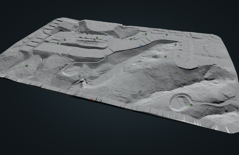
These models are particularly useful for creating Digital Elevation Models (DEMs), which are 3D representations of a terrain’s surface. Thanks to software solutions like Pix4D, these models can be easily created from the data collected by the LiDAR drone.
The Power of LiDAR Drone Surveying
LiDAR drone surveying offers unparalleled accuracy and efficiency in a variety of applications. For instance, construction companies can use this service to conduct land surveys and plan out their projects with maximum precision. On the other hand, environmental scientists can leverage this technology to study deforestation, coastal erosion, and other critical environmental concerns.
This service also comes in handy for agricultural businesses that wish to map their fields and better understand the topography and health of their lands. Similarly, urban planners can use these models to plan and design infrastructure projects more effectively.
Why Choose THE FUTURE 3D for Your LiDAR Drone Services?
At THE FUTURE 3D, we’re proud to offer cutting-edge commercial drone services, including LiDAR drone mapping, to clients across various sectors. We serve locations nationwide in the U.S., including Miami, FL, New York, New Jersey, Connecticut, and Los Angeles.
We leverage top-tier equipment like the ROCK Robotic R3 Pro and the Emlid Reach RS2+ to ensure our LiDAR drone surveying services are of the highest standard. Plus, we manage all our data in the ROCK Cloud, a powerful platform that provides high-quality 3D point cloud visualization and manipulation.
In addition, we also utilize DroneDeploy, a drone mapping software, to further streamline our operations. This allows us to create high-resolution maps and 3D models quickly and efficiently via photogrammetry, ensuring that our clients receive accurate and timely results.
Conclusion
By choosing THE FUTURE 3D for your LiDAR drone services, you’re choosing a partner that values quality, accuracy, and efficiency. We are committed to helping your business leverage modern drone technology to its fullest potential. To learn more about our services or to schedule a consultation, contact us today.
Ready to Start Your Project?
Get a free quote and consultation from our 3D scanning experts.
Get Your Free Quote

