The handheld 3D scanner market has shifted dramatically. Devices that once cost $50,000+ now compete with smartphones, and a new generation of scanners adds Gaussian Splatting output — photorealistic 3D reconstruction that renders in real time at 60+ FPS. This guide compares the leading handheld scanners available in 2026 for professional building and environment scanning applications.
Scanner Categories
Handheld 3D scanners in 2026 fall into three categories:
- Professional SLAM scanners — LiDAR-based wearable/handheld devices designed for building-scale documentation (NavVis VLX 3, Leica BLK2GO)
- GS-capable handheld scanners — New category combining LiDAR capture with direct Gaussian Splatting output (Xgrids L2 Pro)
- Consumer spatial scanners — Lower-cost handheld devices for room-scale capture (3DMakerPro Eagle, phone-based apps)
The key differentiator in 2026 is GS output capability — the ability to produce photorealistic Gaussian Splatting scenes directly from handheld capture, bypassing separate processing pipelines.
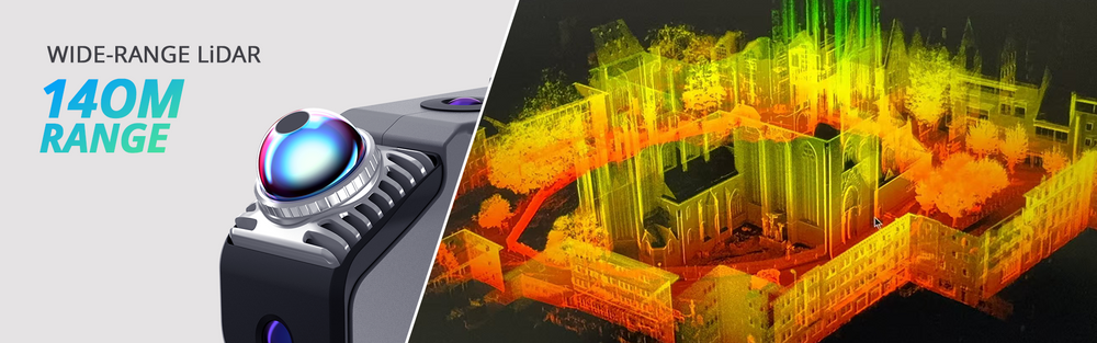
Xgrids L2 Pro: The GS-Capable Professional Scanner

The Xgrids L2 Pro is the first professional handheld scanner designed specifically for Gaussian Splatting workflows.
Specifications
- LiDAR: 32-channel, 640,000 points per second
- Accuracy: ±1–2cm
- Camera: Integrated RGB for texture/GS capture
- Weight: Handheld form factor
- Software: LCC (proprietary cloud/local processing)
- GS Output: Direct Gaussian Splatting via LCC — ~1 hour processing for a 3-minute scan
- Engine SDKs: Unity, Unreal Engine 5, WebGL
- BIM Bridge: LCC for Revit plugin
What Makes It Unique
The Xgrids L2 Pro + LCC software pipeline outputs Gaussian Splatting scenes with direct game engine SDKs. Walk through a building interior with the handheld scanner, and LCC produces an explorable GS scene ready for Unity, UE5, or web viewing — without intermediate processing in DJI Terra or other photogrammetry software.
The LCC for Revit plugin bridges GS-to-BIM workflows, which is notable because GS has zero native CAD/BIM support. This makes the Xgrids ecosystem uniquely positioned for architecture and construction applications where both visualization and BIM documentation are required.
Best For
- Interior walkthrough GS capture for architecture and construction
- Ground-level environment scanning to complement aerial drone GS
- Projects requiring both GS visualization and BIM-compatible output
- Rapid on-site documentation with direct game engine integration
Limitations
- Proprietary LCC format requires Xgrids software ecosystem
- ±1-2cm accuracy is not survey-grade (compared to Trimble X12 at ±2mm)
- Outdoor performance limited by LiDAR range vs aerial drone coverage
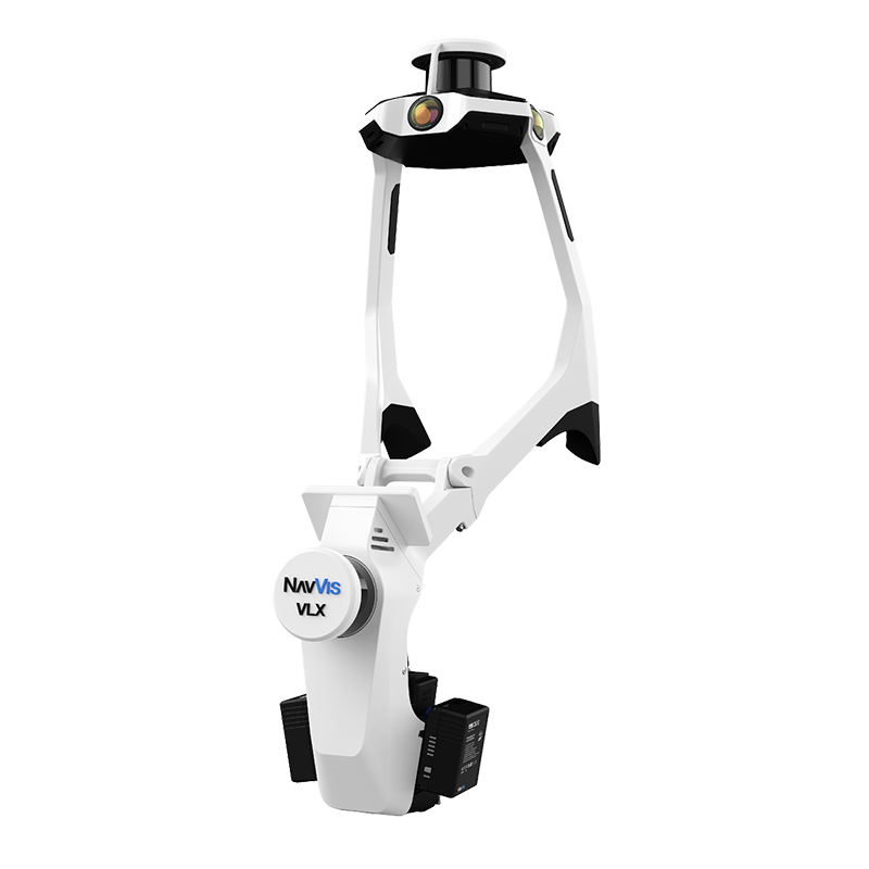
NavVis VLX 3: Professional SLAM Scanner
The NavVis VLX 3 is the current benchmark for professional wearable indoor scanning.
Specifications
- LiDAR: Multi-sensor array, 2.56 million points per second
- Accuracy: ±5mm (relative)
- Weight: 8.5 kg (wearable backpack)
- Cameras: 4× panoramic cameras for 360° imagery
- Software: NavVis IVION (cloud platform)
- GS Output: No native GS — outputs point clouds and 360° panoramic imagery
Best For
- Large-scale indoor scanning: warehouses, hospitals, data centers, retail
- Rapid facility documentation at walking speed
- As-built documentation for facility management
- Projects where capture speed and coverage area are priorities
Limitations
- No native Gaussian Splatting output
- ±5mm accuracy (less precise than tripod-based Trimble X12)
- 8.5 kg weight limits continuous operation time
- Higher price point than GS-specific alternatives
For a detailed VLX 3 review, see our NavVis VLX 3 specifications guide.
3DMakerPro Eagle: Consumer Spatial Scanner
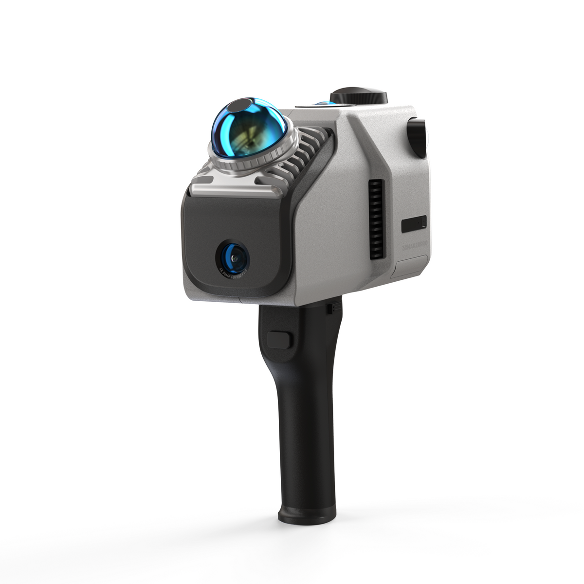
The 3DMakerPro Eagle brings spatial scanning to the consumer/prosumer market at a fraction of professional scanner pricing.
Specifications
- LiDAR: 200,000 points per second
- Camera: 48MP RGB
- Accuracy: Manufacturer-rated (varies by scene)
- Price: $3,398–$3,998
- Software: RayStudio (desktop processing)
- GS Output: Standard PLY and OBJ via RayStudio — compatible with SuperSplat and SplatForge
- Note: RayStudio is the correct software name (not JMStudio)
Best For
- Room-scale spatial scanning on a budget
- Small environment capture (individual rooms, small offices)
- GS scene creation via standard PLY output to SuperSplat/SplatForge
- Education and prototyping applications
Limitations
- 200K pts/sec is significantly slower than professional scanners
- Not designed for building-scale or environment-scale capture
- Processing quality depends on operator technique and scene complexity
- No game engine SDKs (standard file export only)
Phone-Based Scanning: Polycam and Luma AI
Smartphones with LiDAR sensors (iPhone Pro, iPad Pro) have enabled entirely app-based 3D scanning.
Polycam
- Platform: iOS, Android, Web
- Capture: Smartphone LiDAR + camera
- GS Output: Yes — Gaussian Splatting reconstruction from phone captures
- Price: Free tier + paid subscriptions
- Best for: Quick site references, proof-of-concept GS captures, casual documentation
Luma AI
- Platform: iOS + cloud processing
- Capture: Photos from any camera (phone, DSLR, drone)
- GS Output: Yes — cloud-based Gaussian Splatting from uploaded photos
- Price: Free
- Best for: Zero-cost GS proof-of-concept, preliminary location assessment
Limitations of Phone-Based Scanning
- Resolution and detail limited by phone camera/LiDAR quality
- Indoor range limited (effective to ~5 meters for LiDAR)
- No survey-grade accuracy data
- Cannot match professional scanner coverage or quality for building-scale projects
Comparison Table
| Scanner | Points/sec | Accuracy | GS Output | Price | Best For |
|---|---|---|---|---|---|
| Xgrids L2 Pro | 640K | ±1-2cm | Direct (LCC) | Contact Xgrids | GS walkthrough capture |
| NavVis VLX 3 | 2.56M | ±5mm | No | Contact NavVis | Large indoor facilities |
| 3DMakerPro Eagle | 200K | Varies | Standard PLY | $3,398-$3,998 | Room-scale on budget |
| Polycam | Phone LiDAR | Low | Yes | Free/subscription | Quick references |
| Luma AI | N/A (photos) | Low | Yes (cloud) | Free | Proof-of-concept |
How Handheld Scanners Complement Drone Capture
For building-scale and environment-scale projects, no single handheld scanner covers everything. The professional workflow combines:
-
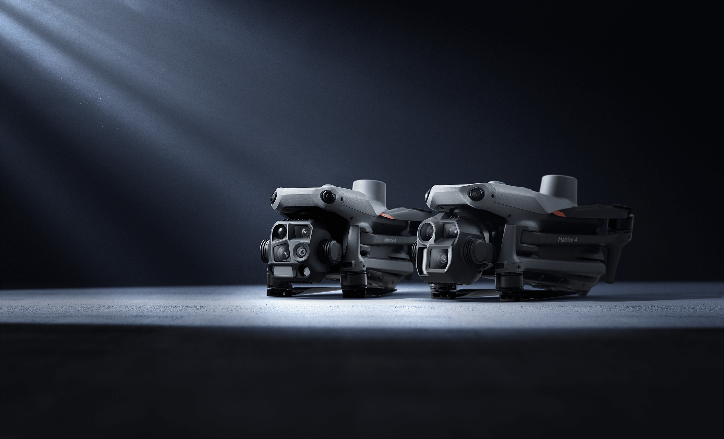
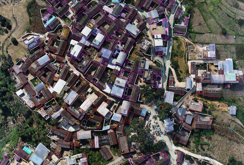
Aerial drone GS (DJI M4E + DJI Terra) — Captures rooftops, facades, surrounding context from above. Handles building exteriors at scale. Up to 30,000 images.
-
Handheld ground-level GS (Xgrids L2 Pro) — Fills in areas drones cannot reach: interior spaces, ground-level facades, covered walkways, courtyards. Direct GS output via LCC.
-
Survey-grade LiDAR (Trimble X12) — Provides ±2mm dimensional data for measurement and BIM workflows. Not a GS tool but essential for hybrid deliveries.
-
Scene editing (SuperSplat + SplatForge) — Merges aerial and ground-level GS captures, removes artifacts, and optimizes for delivery.
THE FUTURE 3D deploys this multi-sensor approach on projects requiring both photorealistic GS visualization and survey-grade measurement data, producing both from a single site visit.
When to Use Handheld vs Drone vs Tripod
| Scenario | Recommended Scanner | Why |
|---|---|---|
| Building interior | Xgrids L2 Pro or NavVis VLX 3 | Walk-through capture at human scale |
| Building exterior | DJI M4E + Zenmuse P1 (drone) | Aerial coverage of facades and rooftops |
| Single room | Polycam or 3DMakerPro Eagle | Quick capture, limited scope |
| Large warehouse | NavVis VLX 3 | Speed at scale (2.56M pts/sec) |
| Construction site | DJI M4E (aerial) + Xgrids L2 Pro (ground) | Multi-sensor hybrid |
| Heritage interior | Xgrids L2 Pro + Trimble X12 | GS visuals + survey measurement |
| Quick reference | Polycam or Luma AI (phone) | Free, instant, no equipment needed |
Choosing the Right Scanner
If your priority is Gaussian Splatting output:
→ Xgrids L2 Pro for professional quality with direct game engine SDKs → Polycam for free consumer-grade GS from your phone
If your priority is scanning speed and coverage:
→ NavVis VLX 3 at 2.56M pts/sec for the fastest large-area coverage → DJI M4E drone for the fastest outdoor/aerial coverage
If your priority is accuracy:
→ Trimble X12 at ±2mm for survey-grade (tripod-based, not handheld) → NavVis VLX 3 at ±5mm for the most accurate handheld option
If your budget is limited:
→ 3DMakerPro Eagle at $3,398-$3,998 for the lowest-cost hardware → Polycam (free) or Luma AI (free) for zero-cost entry
Find Your Ideal Scanning Method
Not sure which approach is right for your project? Try our GS Method Selector — a 5-question quiz that recommends the optimal scanning method based on your use case, accuracy needs, scale, and budget.
For professional scanning services using all of the above equipment, contact THE FUTURE 3D for a custom project quote.
THE FUTURE 3D deploys a multi-sensor fleet including DJI M4E drones, Trimble X12 LiDAR, and NavVis VLX 3 — with the Xgrids L2 Pro currently in our evaluation pipeline. Professional Gaussian Splatting services from $2,250. Learn more about our GS capabilities.
Ready to Start Your Project?
Get a free quote and consultation from our 3D scanning experts.
Get Your Free Quote