Golf course renovation is a multi-million dollar undertaking that depends entirely on the quality of existing conditions data. When the terrain model is wrong, everything downstream — grading plans, drainage design, earthwork quantities, and construction budgets — is wrong with it.
Golf course architects have traditionally relied on topographic surveys produced by ground crews with total stations. These surveys are accurate at measured points but sparse between them. A typical ground survey might capture 5,000-10,000 elevation points across an 18-hole course. A LiDAR drone survey captures 50-100 million points across the same area, producing a terrain model with centimeter-level detail that transforms the design process.
What Golf Course Architects Need
The data requirements for course renovation design are more demanding than most people realize. Architects are not just looking at overall topography — they are designing terrain features measured in inches.
Existing Conditions at Centimeter Resolution
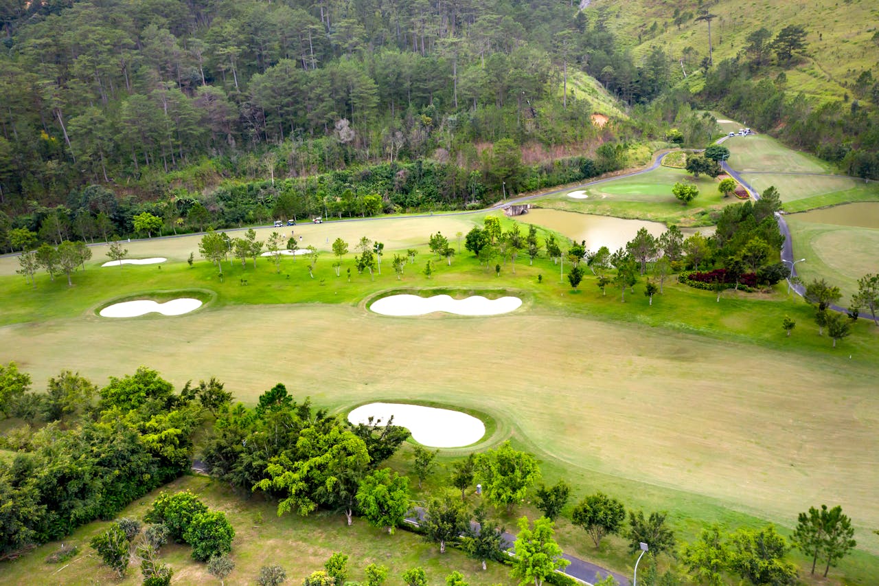
A golf course green has subtle contours that determine how a ball rolls. The difference between a 1% slope and a 2% slope on a putting surface is the difference between a fair hole and an unplayable one. Renovation design for greens requires terrain data accurate to ±2-3 centimeters at minimum.

Architects need this level of detail across:
- Greens and surrounds: Surface contours, drainage slopes, collar elevations
- Tee complexes: Tee surface grades, slope to fairway, retaining wall heights
- Bunkers: Sand depth, lip heights, drainage grades, floor elevations
- Fairways: Landing zone contours, lateral slopes, rough transition grades
- Water features: Edge geometry, depth transitions, overflow elevations
Cut/Fill Volume Calculations
Every renovation project that moves earth needs volume estimates. LiDAR terrain data provides the existing surface; the architect’s grading plan provides the proposed surface. The difference between the two — calculated automatically in 3D modeling software — gives precise cut (material removed) and fill (material added) volumes.
These volume calculations directly determine:
- Earthwork contractor bids: Contractors price based on cubic yards of material moved
- Hauling costs: Material that cannot be balanced on-site must be imported or exported
- Project schedules: Earthwork duration depends on volume and equipment capacity
- Environmental impact: Grading permits in many jurisdictions require earthwork quantity estimates
With LiDAR data, volume calculations are typically accurate to within 1-3% of actual moved material. With traditional survey data (interpolated between sparse points), accuracy can vary by 10-20%.
The Problem with Traditional Surveys
Traditional topographic surveys using total stations and GPS produce data points that are individually accurate to ±10-15mm. The problem is not accuracy at individual points — it is the density of coverage between points.
Interpolation Error
Ground survey crews measure discrete points — top-of-slope, bottom-of-slope, grade breaks, and features. Software interpolates the surface between measured points. On a golf course where terrain varies continuously, the interpolated surface often misses subtle features that affect design:
- Micro-depressions that collect water
- Subtle ridge lines that redirect drainage
- Grade transitions that appear smooth in interpolated data but are actually abrupt
- Buried drain structures that create surface depressions not captured by sparse measurement
Time and Cost
A comprehensive topographic survey of an 18-hole course takes 2-4 weeks of field work with a 2-3 person crew. At current survey crew rates, the field work alone costs $15,000-$30,000+.
A drone LiDAR survey captures more data in 1-2 days at $5,000-$15,000 total including processing and deliverables.
LiDAR Delivers What Architects Actually Use

The deliverables from a golf course LiDAR survey map directly to the inputs that architects need for renovation design.
Digital Terrain Model (DTM)
The bare-earth surface model is the primary design input. The architect loads the DTM into Civil 3D, Bentley, or similar grading software and designs the proposed terrain modifications as a new surface. The software calculates cut/fill volumes, generates cross-sections, and produces the grading plan.
Cross-Sections
Architects extract cross-sections through specific holes to study existing terrain in profile view. These sections show slope angles, grade transitions, and elevation relationships that are difficult to interpret from contour maps alone.
Contour Maps
Traditional 1-foot contour maps remain a standard deliverable for plan sets. LiDAR data produces smoother, more accurate contours than interpolated survey data because the point density is orders of magnitude higher.
As-Built vs Design Overlay
For courses that have been previously renovated, the LiDAR DTM serves as the as-built record. Comparing the as-built surface to the original design reveals construction deviations, settlement, and erosion that inform the next renovation cycle.
Design Verification: As-Built vs Design Comparison
One of the most valuable applications of LiDAR for golf course work happens after construction, not before. A post-construction LiDAR survey produces an as-built DTM that can be overlaid on the design DTM to verify that what was built matches what was designed.
Why This Matters
Golf course earthwork is performed by heavy equipment operators working to grade stakes and laser levels. The precision of the finished surface depends on operator skill, equipment accuracy, and site conditions. Deviations from design are common:
- Green surfaces finished 2-3 inches above or below design grade
- Bunker lips higher or lower than specified
- Drainage grades that miss the design slope by enough to affect performance
- Fill areas that settle differentially after construction
The Verification Process
- Pre-construction LiDAR scan: Establishes the existing conditions baseline
- Design model: The architect’s proposed grading plan (imported from Civil 3D or similar)
- Post-construction LiDAR scan: Captures the as-built surface after earthwork is complete
- Comparison analysis: Software overlays the as-built surface on the design surface and generates a difference map showing areas of conformance and deviation
The result is a heat map showing exactly where the built surface matches the design and where it deviates. Areas with unacceptable deviation can be corrected before the turf is established — a far less expensive fix than regrading after grow-in.
How Course Architects Use Drone Data
Companies like GeoGolfMap specialize in topographic mapping specifically for golf course architecture. The workflow they and similar firms follow demonstrates how the industry is integrating drone survey data into the design process.
The Modern Renovation Workflow
- Commission drone LiDAR survey of the existing course
- Process DTM and deliverables in survey-grade accuracy
- Import DTM into design software as the existing conditions surface
- Design proposed modifications as new surfaces over the existing conditions
- Calculate earthwork volumes automatically from the surface comparison
- Generate construction documents with grading plans, cross-sections, and quantity estimates
- Post-construction verification scan to confirm as-built matches design
This workflow produces better design outcomes in less time at lower total project cost than traditional methods.
Frequently Asked Questions
What accuracy does golf course renovation design require? Green renovation typically requires ±2-3cm vertical accuracy. Fairway grading design requires ±5cm. Rough grading and site work require ±10cm. LiDAR drone surveys with RTK/PPK positioning meet all of these requirements.
Can LiDAR data replace a full topographic survey? For most golf course renovation projects, LiDAR provides superior data to traditional topographic surveys. The exception is subsurface utilities and buried infrastructure, which require separate investigation methods (ground-penetrating radar or utility locating services).
How do architects receive the data? Standard deliverable formats include AutoCAD DWG files with contours and spot elevations, Civil 3D TIN surface files, LandXML exports, and GeoTIFF rasters. Most architects have a preferred format — discuss this during the quoting process.
When should the survey be done relative to construction start? Survey the course 2-6 months before design begins. This allows time for processing, design development, and permitting. A second survey immediately before construction captures any changes since the initial survey. A third survey after construction verifies the as-built conditions.
Explore our golf course LiDAR mapping services and as-built documentation capabilities. For the technology behind course surveys, read our golf course survey technology guide.
Ready to Start Your Project?
Get a free quote and consultation from our 3D scanning experts.
Get Your Free Quote

