
LiDAR vs. Photogrammetry Drones: A Comprehensive Guide
The use of drone technology has seen explosive growth across a wide range of industries. This surge can largely be attributed to the advanced capabilities drones offer through two main technologies: LiDAR and Photogrammetry. Each technique has its strengths and applicability, and understanding their differences is crucial in choosing the right tool for your project.
Let’s delve into the fascinating world of LiDAR and Photogrammetry drones, exploring their functionalities, technical aspects, pros, cons, and optimal use-cases.
LiDAR Drones
LiDAR, or Light Detection and Ranging, employs a pulsating laser to calculate the distance between the drone and the ground surface. Paired with GPS and IMU data, this allows the creation of detailed and precise three-dimensional representations of the surveyed area. A sophisticated drone like the DJI Matrice 350 RTK, armed with ROCK R3 PRO LiDAR sensor, can accurately map even the most complex terrains.
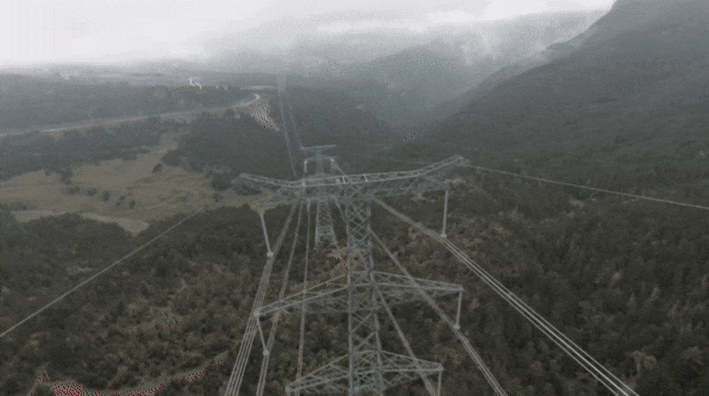
Pros: The key advantage of LiDAR is its ability to penetrate dense vegetation and reach the ground surface, thus providing true ground-level data. It also performs exceptionally well under all light conditions and can map large areas swiftly, making it a time-effective choice. LiDAR is also the best solution for picking up small details, like utility power lines. With the latest advancements in the hardware and software, it is possible to achieve 1-cm accurate colorized color points in just a few hours!
Cons: Despite the many advantages, LiDAR can be an expensive solution. The high cost is driven by the expensive sensors and the computational power needed to process the vast amounts of data they collect.
Use Cases: Infrastructure projects, Topography Mapping, Digital Elevation Modeling & Contours, Vegetation Management, Forestry Mapping, Stockpile Analysis, Volumetric Calculations, Flood Risk Management, and Coastal Erosion Studies are fields where LiDAR shines.
Photogrammetry Drones
Photogrammetry involves capturing high-resolution overlapping images together with RTK + GNSS Base GPS data, which are then processed using software like Pix4D or DroneDeploy to generate detailed, textured 3D models or 2D maps. Drones equipped with high-end cameras, like Mavic 3 Enterprise RTK, are typically used for this purpose.
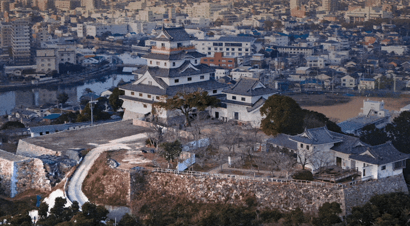
Pros: Photogrammetry excels in capturing the color and texture of the terrain, making the final output visually rich and appealing. This technology is also more budget-friendly than LiDAR. With proper hardware, software and expertise, it is possible to achieve sub-1 cm level accuracy in optimal weather conditions.
Cons: Photogrammetry’s performance can be influenced by the lighting conditions at the time of the flight and can struggle with dense vegetation or reflective surfaces.
Use Cases: Applications where visual detail is paramount, such as Orthomosaic Mapping, Photogrammetric 3D Modeling, Facade Orthomosaics, Facade / Roof Inspection, Real Estate, Agriculture, Environmental Monitoring, and Cultural Heritage Preservation.
LiDAR vs. Photogrammetry: Making the Right Choice
The decision to use LiDAR or photogrammetry primarily depends on the project requirements and budget constraints. LiDAR’s precision and ability to penetrate vegetation make it a preferred choice for projects demanding high accuracy, such as urban planning or infrastructure development. On the other hand, photogrammetry’s ability to capture rich, textured, and colored 3D models makes it ideal for projects where visual appeal and detail are essential, such as real estate promotion or heritage site documentation.
Remember that these technologies are not mutually exclusive and can often complement each other. For example, LiDAR can provide the accurate topographic base, while photogrammetry adds the rich textured detail on top.
What Industry Professionals Say
“For our utility corridor work, we run both LiDAR and photogrammetry. LiDAR for the terrain model, photogrammetry for the visual inspection. Best of both worlds.” — Corridor Mapping Professional, r/UAVmapping
“With proper GCPs, we’re hitting 2cm accuracy consistently with photogrammetry. The key is flight planning and using a mechanical shutter drone.” — Photogrammetry Specialist, r/photogrammetry
“The 5-return mode cuts through canopy like nothing else. Forestry clients are blown away by what LiDAR captures under dense vegetation.” — Forestry Mapping Professional, r/UAVmapping
Conclusion
Drone technology, paired with either LiDAR or photogrammetry, is an incredibly powerful tool that has revolutionized numerous industries. By understanding their nuances, you can harness their potential to meet your project needs effectively and efficiently. For expert advice and services in this field, consider partnering with an experienced commercial drone service provider like us: THE FUTURE 3D. Our expertise in providing tailored drone services across Miami, New York, New Jersey, Connecticut, Los Angeles, and nationwide U.S., will help you tap into the transformative power of drone technology effectively.
And if you’d rather fly these missions yourself, we sell aircraft from our own fleet: a brand-new DJI Matrice 400 enterprise drone is currently for sale — the platform that carries the Zenmuse L3 LiDAR payload discussed above — shipped free within the contiguous US.
Ready to Start Your Project?
Get a free quote and consultation from our 3D scanning experts.
Get Your Free Quote

